From Wikipedia, the free encyclopedia
For another town founded under this name, see Washington, Kentucky.
Not to be confused with Little Washington, Virginia or Washington County, Virginia.
| Washington, Virginia | |
|---|---|
| Town | |

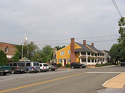
Central intersection in Washington
|
|
 Location of Washington, Virginia |
|
| Coordinates: 38°42′46″N 78°9′34″WCoordinates: 38°42′46″N 78°9′34″W | |
| Country | United States |
| State | Virginia |
| County | Rappahannock |
| Named for | George Washington |
| Area | |
| • Total | 0.3 sq mi (0.7 km2) |
| • Land | 0.3 sq mi (0.7 km2) |
| • Water | 0.0 sq mi (0.0 km2) |
| Elevation | 682 ft (208 m) |
| Population (2010) | |
| • Total | 135 |
| Time zone | Eastern (EST) (UTC-5) |
| • Summer (DST) | EDT (UTC-4) |
| ZIP code | 22747 |
| Area code(s) | 540 |
| FIPS code | 51-83248[1] |
| GNIS feature ID | 1500280[2] |

No comments:
Post a Comment